Research Highlights
Spatial representation of high latitude soil properties in CMIP5 ESMs
May 2, 2016
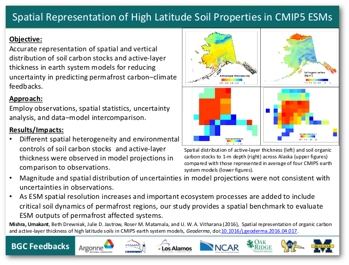
Objective
Accurate representation of spatial and vertical distribution of soil carbon stocks and active-layer thickness in earth system models for reducing uncertainty in predicting permafrost carbon–climate feedbacks.
Approach
Employ observations, spatial statistics, uncertainty analysis, and data–model intercomparison.
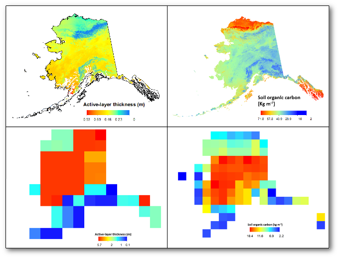 |
Spatial distribution of active-layer thickness (left) and soil organic carbon stocks to 1-m depth (right) across Alaska (upper figures) compared with those represented in the average of four CMIP5 earth system models (lower figures). |
Results/Impacts
- Different spatial heterogeneity and environmental controls of soil carbon stocks and active-layer thickness were observed in model projections in comparison to observations.
- Magnitude and spatial distribution of uncertainties in model projections were not consistent with uncertainties in observations.
- As ESM spatial resolution increases and important ecosystem processes are added to include critical soil dynamics of permafrost regions, our study provides a spatial benchmark to evaluate ESM outputs of permafrost affected systems.
Mishra, Umakant, Beth Drewniak, Julie D. Jastrow, Roser M. Matamala, and U. W. A. Vitharana. May 4, 2016. “Spatial Representation of Organic Carbon and Active-layer Thickness of High Latitude Soils in CMIP5 Earth System Models.” Geoderma. doi:10.1016/j.geoderma.2016.04.017.